Saklang
Traverse Jaro-Ormoc Mountain Ranges
 As darkness sets in and visibility becomes fuzzy because of the rain
and fog, we keep on scaling the northeast ridgeline section of Alto
Peak for the past eleven hours on the first day of our 3-day traverse
starting November 30. Our goal is to reach an abandoned access
road just below the peak of Alto. This access road was used by PNOC
in their drilling operation years before. This is where we want to
establish our Camp 1 as base. From there we decide to assault the
peak or traverse to Ormoc passing through the crater lake of Janagdan.
As darkness sets in and visibility becomes fuzzy because of the rain
and fog, we keep on scaling the northeast ridgeline section of Alto
Peak for the past eleven hours on the first day of our 3-day traverse
starting November 30. Our goal is to reach an abandoned access
road just below the peak of Alto. This access road was used by PNOC
in their drilling operation years before. This is where we want to
establish our Camp 1 as base. From there we decide to assault the
peak or traverse to Ormoc passing through the crater lake of Janagdan.
It is pitch dark. The rain is hard. Everybody is cold and hungry. Using our headlamps and flashlights, we navigate under thick forest cover. From where we stand, we are a kilometer short from Camp 1 according to our GPS reading.
Alto Peak is the highest point in the Amandiwing Range located between the boundary of Jaro and Ormoc City. Volcanic in origin, Alto Peak harbors geothermal energy. PNOC used to utilize this energy by drilling holes through it before. Having no clear dry season, Alto Peak is always covered with fog, mist and clouds. On a clear day, the ideal time to observe the peak is during early morning, noon or late afternoon. In between of the day, the peak is enveloped by thick clouds. It is on this rare occasion that you can observe the mountain in all its glory. You can see the shape of the peak like a sharpened pencil.
Alto Peak has always captivated our imagination. Like Mt. Sayao in Caibiran, Biliran, we have always been attracted to it. In Mt. Sayao, we have to grapple a pure slab of vertical wall 150 meters high to the peak. In Alto you have to grapple with the changing weather near the peak. In 1995 we set out an ambitious plan to traverse Ormoc-Jaro through the Amandiwing Range. We started trekking at the junction to Tongonan late night. Jeffrey, Joey, Eb-Eb, Bimboy and I trekked in the dead of the night following the road from Ormoc to the PNOC drilling site in Alto Peak. Because of poor visibility and bad weather on the second day, we plotted our course how we can traverse to the other side of Jaro instead of making the kill to the peak. Using our compass and topo map, we reached Jaro on the third day. It was the first known traverse by local mountaineers. It would later inspire us to make a successful traverse too in Tres Marias from Culaba to Naval in Biliran Island in 1998.
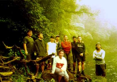
Six years since the last time we traversed the Amandiwing Range, Joey, Jay and I decided to embark for another Alto Peak exploration. This time bringing along with us some of the new SAKLANG members RICHARD, Team Captain of one of the SAKLANG teams which placed second in the Nov 2001 La Routa Mini Adventure Race, BABADS, freshman law student in RTR, TATA, competitor in the 2001 Carera Habagat held in Siquijor and Urban Jungle in Cebu, DODOT, passionate rock climber and JENNYLYN, senior Psych Major in UP Tacloban College.
Our plan is to start in Jaro, climb all the way to the base and if time and weather allow, attempt to find a route to the summit from the north ridge section. From the summit we would trek back to the base and navigate towards Barangay Cabintan, Ormoc City, which is approximately two hours trek from the base. We figured that if we really want to reach the peak, we must find a way to the base and reach there by noon on the first day so that we can have a headstart to assault the peak in the afternoon. We braced ourselves with the thought we might spend the night in a treacherous slope halfway to the summit of Alto Peak. In three days of climbing, we figured we could reach the summit, scale Lake Janagdan and traverse to Ormoc.
What makes the attempt to reach the summit during November rain tricky is that you dont have a chance to take a peek of the peak most often, the peak is shrouded with clouds. There is no known account of local mountaineers having reached the summit except perhaps with locals in the area gathering uway. And the best topo map you can get from NAMRIA in DENR is the one with the words clouds inscribed on the elevation of Alto. The best you can do with it is trace imaginary contour lines and figure out where the possible ridgeline connecting the peak lies. The terrain towards the peak is characterized by deep crevasses with sulfuric fumes wafting from below, cliffs and vertical ridges.
The way SAKLANG conducts its exploration climbs has most often raised eyebrows from some mountaineers. It is because SAKLANG dont hire guides or porters to take us from Point A to Point B as a matter of practice and principle. We have learned to become a self-contained, autonomous unit, bunking on our cohesiveness and teamwork, polishing our skills in navigation and mastering jungle survival techniques. We use maps, navigational instruments like compass and GPS, and a clear background research of the area to make any exploration climbs safe, secure and rewarding. With maps and careful planning, we can plan to start anywhere or zero in on a particular area. We can track down an established route and follow it or we can make our trails where there is none to reach our goal.
With guides, the breadth of exploration is limited to the breadth of his knowledge in the area. The team becomes dependent to the guide. If he becomes disoriented, the whole team is disoriented. But if all of you have a relative knowledge of reading the maps and a degree of confidence in navigation, there is a wide room for flexibility in terms of route planning and creativity in reaching your goal, which is what we have been practicing through the years. Besides, can you honestly consider it as an exploration climb if you pick-up a guide?
Our initial plan is to hit the trail to Rubas, Jaro but because of security concerns, we decided at the last minute to plot a different course starting at Canhandugan. We hit trail in the morning of November 30 not knowing what lies ahead of us on the following days to come. We feel that after months of careful planning and preparation, the time has come to take a second shot to Alto Peak.
Jay, my team member in the 2001 Carera Habagat held in Siquijor, takes the lead while Joey and I sweep the trail. Dodot, Babads and Richard trail behind Jay while Tata assists Jennylyn, our lone female companion, carry her backpack.
Midway we take a GPS reading to cross the Mainit River so that we can follow the ridge that serves as backbone towards the base of the peak. We plot our position on the map, calculate our distance covered and the distance from our current position to our goal, which is the base. I figured that with our current pace we should be at the base by noon an estimate that, as we would realize later, underestimated the nature of the terrain.
Jay takes the push towards the ridgeline. And as we ascend the vertical slippery slope below the ridge across Mainit River, Jennylyn, a neophyte mountaineering enthusiast, slip, fall flat on her body. Instead of getting scared, she managed to flash a quick smile while everybody shouted: "Welcome to the club!" Its so exciting, she says, while posing for a quick shot from Tata.
With no trail in sight we plot our course again and keep pushing to the top of the ridge. As we reach the top of the ridge, we can see across us the base of Alto Peak dotted with second growth pine trees. The peak is hidden behind thick clouds and we are enveloped by fog. A cold chill runs through our spine. Its so cold standing there at the top of the ridge.
To reach the base, we have to descend from the ridge and traverse a thick forest cover with no trails in sight. From the map we can observe a vertical slope lies ahead of us 300 feet deep. At this point, we take our lunch amidst the swarms of mosquitoes.
;This time, Jay and I take the lead. As I plot our course on the map looking for a secure route, Jay takes my jungle bolo and hack his way through our desired course. We reach a clearing an area where we can see the sky and feel the warmth of the sun. There in the deep forest cover we come across a lake west from where we stand. We marvel of its beauty. If you really want to reach this lake, you really have to hack your way through, Joey quips.
Across us looms the base of Alto Peak. To reach the base, we have to negotiate a 300 feet deep descend, walk across the open field and ascend 900 feet high with no trails. But its not easy as it seems.
The weather is erratic. To the east, a dark, heavy clouds creep slowly as if calculating when to unleash its fury. A thick fog blocks our visibility. We are racing against time. Its nearly 2 in the afternoon and we are still deep down below the base. I figured if we can cover the stretch in an hour, we still have ample time perhaps to take a shot to the peak before fog and clouds fully cover it.
Conscious of the weather and time we start to negotiate the 300 feet deep descend. We reach a stream, take a small break and replenish our water supplies. We follow a tract to the open field hoping it would lead up to the base. Upon reaching the open field the trail runs through from east to west. In front of us is the 900 feet vertical slop to the base. There is no trail going south-southwest, which is our general bearing. Here we face a dilemma.
If we hack our way to the south and start to climb the 900 feet slope, we might end up sleeping beside the treacherous vertical slope prone to quick landslide, an area that is still far from the base according to my GPS. With bad weather approaching, we cannot afford to take the risk. If we take the trail to the west, we would end up circling the mountains far from our target. We realize however that if we follow this trail while rain and darkness set in, we can gamble to trek in the night to reach Camp 1. If we take the trail to the east, we will absolutely be off-course!
Jay and I decide to take the trail going west. Just as we are about to trek, a light drizzle cautioned us of a bad weather approaching.
Weather pattern in Alto Peak is unpredictable. One moment, the sun is out. Next moment, clouds set in. One moment you feel a fine weather. Next moment you endure the heavy rain. Because we are way behind now of our time estimate to the base and the thought of an impending bad weather, everybody feel our bid to explore the summit from the base through the north ridgeline is gone. We know that if we force our way to the top, we cannot finish the whole traverse in three days. The best we can do is plot our course to Camp 1 before night falls.
There are many trails ahead of us enough to be confused. Jay keeps asking about our bearing to make sure we hit the right trail to follow. The wind is cold and the rain is getting furious. We follow a trail passing through a river. We cross the river. The trail shoots up vertically towards another ridgeline. We maintain our pace like a rhythm following a monotonous beat. Jay hopes his knees wont give up as much as I do. I tell him to go ahead while I wait for Jennylyn, Tata, Babads, Richard, Dodot and Joey nursing from muscle cramps. We take a rest along the trail to prepare for the night trek under heavy rains.
Trekking under the cover of darkness is the perfect time to test ones resolve to keep pushing the limits be it fear of the environment or fear of yourself. In exploration climb like this, time is of the essence and motivation is the driving force. We know we are way down behind our time but our motivation to reach our goal keep us pushing our personal limitations to the edge. I have no qualms with my teammates during the night trek. They have been practicing for past months navigating in the dark.
We have been trekking for the past eleven hours already and my GPS reading reveals we are a kilometer short from the base. The base is near, I say. Jen is tired and Tata is hungry. Dodot, Richard and Babads endure the cold while Joey keeps guarding his knees. Jay and I hope our knees wont give up. We are already dead tired too. Still far?, Jen asks. Not very far, I say.
Besieged by fog, cold and rain, we keep on trekking under thick forest cover in the night. We scale a sloping terrain where we can see pine trees everywhere, an indication we are very near from the base. Jay beams a wide smile. I know why. He makes a mad dash. He looks around. This is it, he says. I look around and everybody is smiling. Here we are, I say. To them, reaching the base is a big relief. Sort of youre in a tantric state the soul is high and strength recharged.
To me, reaching the base is an affirmation of our collective effort and teamwork and mental discipline to hurdle limitations and obstacles. We reach an abandoned access road. To our right just below the edge of a cliff a waterfalls cascade gently. Looking at the waterfalls is enough to soothe our soul. We make our camps near the waterfalls amidst thick fog and cold wind. Dodot, our chief cook, prepares the food while Jay and Tata pitch the tents. We feast on hot noodles, canned goods, warm rice and milo. Joey suggests we trek after dinner to the nearest barangay in Ormoc approximately two hours from where we are. No problem, I say. But after we feasted on our food, all we had on our mind was to take a good sleep. As rains pelted our tents, we have nothing much to do but take a good sleep.
We wake up early morning under a thick fog. Cold and chilly, we break our camp and treat ourselves to a warm milo and food. We linger a bit while having our breakfast. We know we have a long and demanding day ahead of us. We must reach Barangay Cabintan before 10 in the morning. Two of our friends, Cyril and Rannie, will be waiting for us there. They will go with us to scale Lake Janagdan.
Before we leave to Lake Janagdan, I take a GPS reading of our current position. I plot our position on the map and calculate the approximate distance to Lake Janagdan. I figured we could reach Janagdan before 5 pm.
Moving west, we go to the rhythm of our feet, gazing at the thick fog covering us. Northwest from our position we cannot see Jaro and nearby municipalities. Usually on a clear day, one can see the plains from Carigara to Palo. One can even observe the jagged north face of Mt Danglay in Samar!
After more than an hour of trekking from the base, we reach a junction. To the left is a deep cliff where wisps of smoke from sulfuric fumes waft to the air. At this point, we meet Cyril and Rannie. Cyril would tell us later that they decided to stop at this junction because theyre unsure which way to go. We reach Cabintan by noon and decide to take our lunch there.
In the afternoon we hit the trail to Lake Janagdan gently scaling the 3960 feet crater lake. We reach Lake Janagdan at 4:00 pm. Jay observes the lake swells. So he scouts a place for three tents to pitch. Jay, Babads and I decide to pitch our tent on a slightly elevated, rocky surface while the group of Joey and Tata settle on a place few meters east from where the trail to Lake Janagdan ends.
It is slightly dark. The fog covers the lake. A cold breeze and mist prevail while we huddle around the cook-set to warm our bodies. Jen takes advantage to catch a nap while waiting for dinner. As usual our dinner is not complete without a hot soup of noodles.
In the morning after breakfast, Jay and I decide to take a plunge into the lake. It is pretty cold. But the water is fresh and clean an ideal place to swim. We trek down from the crater lake to Barangay Cabintan. We reach Cabintan by noon just in time for us to take a quick bath while we wait for the jeep bound to Ormoc to pass by.
Feeling clean, fresh and relieved, we wait for the jeep to pass by. We take the jeep bound to Ormoc. Our eyes gaze everywhere at the fields, mountains and the range and ridges we pass through for three days.
We are amused and well, glad, for having reach this far from the thick forest cover of Jaro to the base, to the long trek to Cabintan and the ascent to Lake Janagdan.
For Joey and I, this is our second time to traverse the mountain range. The first, from Ormoc to Jaro in 1995 using different routes. For Tata, Jay, Dodot, Richard, Babads and Jennylyn, it is their first.
Be it our second or our first, the beauty of making it through in any exploration climbs is a new kind of personal experience that we can only feel. We learn more about our inner self, we deepen our bonding with our team members, and we imbibe a deep sense of respect for nature.
The beauty lies not only on being there and making it through. Knowing more about our inner selves is, for me, the best reward of all.
|